Name of Indicator Source- Bangladesh Data Sheet, BBS |
A. GEOGRAPHY |
Location |
Between 20°34' and 26°38' north latitude and
Between 80°01' and 92°41' east longitude |
Boundary |
North and West: India; South: Bay of Bengal; East: India & Myanmar |
Area (Sq.Km.) |
147,570 Sq. Km.(56,977 Sq. miles) |
Territorial Water |
12 Nautical miles |
Standard Time |
GMT+ 6 hrs |
Rainfall |
203 mm/month |
|
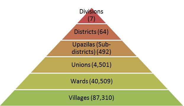
B. ADMINISTRATION |
Division |
7 |
City Corporation |
10 |
Metropolitan City |
4 |
Municipality |
277 |
Districts |
64 |
Upazila |
492 |
Union |
4,501 |
Wards |
40,509 |
Village (approximately) |
87,310 |
Household |
3,18,63,396 |
Average size of Household |
4.6 SVRS 2010 |
|
 |
